
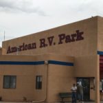
We made it. We’re in Albuquerque, NM at the American RV Park just west on I-40. We spent two days transiting from Branson to Albuquerque with an overnight at a KOA in El Reno, OK. It was a long haul through the “fly-over states” of Oklahoma and part of Texas. Bill (who did all the driving) was pretty tired by the time we got here. We climbed from an elevation of about 800 feet in Branson to 1200 feet around Oklahoma City to 7000 feet along I-40 before dropping to 5300 feet in Albuquerque. We had no idea that we would see that much altitude change.
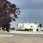
American RV Park is a really nice campground just off the highway. The newer sites have big concrete pads and are landscaped with either grass or stones. Some have mature trees while others (like our site) have what appears to be a newly planted tree. We hear traffic noise from the highway but it’s not bad.
Thursday morning we drive into the Old Town for our private walking history tour with Tours of Old Town. We meet our guide, Chuck, at their ticket window in Plaza Don Luis. For the next two hours Chuck tells us about the history of the area and the establishment of the city as we walk the streets of Old Town. His story starts about ten million years ago when the Sandia Mountains rise as part of the Rio Grande Rift. Volcanic in origin, there are five (now extinct) volcanoes around the city. His story continues as he tells us of the first known inhabitants of the area – the Anasazi or Ancient Puebloans – who lived here until around 1300 A.D. when they mysteriously abandoned the area. In 1540 Conquistador Francisco Vasquez de Coronado came in search of the mythical Seven Cities of Cibola. Even though he left empty handed, other Spanish settlers soon followed.

In 1706, Don Francisco Cuervo y Valdez, the provisional governor of the territory, petitioned the Spanish government to establish the area as a formal villa and call it Alburquerque after the Duke of Alburquerque. The spelling was later changed but the nickname “Duke City” remained. Bolstered by the railroad in 1880 and Route 66 in the 1930’s Albuquerque quickly grew into a major city.

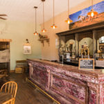
We stop in High Noon Restaurant and Saloon, built in 1785 to view the interior. This structure has a varied past including a brothel and later a convent. As we continue our walk, Chuck points out the adobe architecture and how it has changed over the years.
Next, we “break” into the Candy Lady shop where the blue rock crystal candy used in the tv show Breaking Bad as a stage prop for meth is made. Bill just has to get into the act.

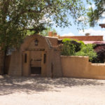
Our tour concludes outside San Felipe de Neri church which was constructed in 1793 after three previous adobe structures had been washed away by flooding from the nearby Rio Grande river. We pop in for a quick look and then browse the shops before returning to the High Noon for lunch.
We spend Friday around the campground as Bill attempts to find a mobile RV repair service to come fix a roof leak around the skylight in the bathroom. Later in the afternoon we do a two mile walk around the campground for some exercise. I can tell that we’re no longer at sea level.
Saturday we decide to drive up the Turquoise Trail to Santa Fe. The drive is about 50 miles through a number of mining towns. Our route out of Albuquerque takes us to famous Route 66 and the Singing Road where, by obeying the speed limit and positioning the tires on the grooves, the road “sings” America the Beautiful. You must listen carefully as the “song” is not very long. At Tijeras we turn north onto the Turquoise Trail. We pass through the small town of Cedar Crest and come to the turn off to Sandia Park. We debate about driving to Sandia Crest but decided to either take the tram later today or come back next week. After passing through Golden, we stop at Madrid to walk around and explore some of the shops. We find a place to park outside of Maggie’s Diner from the movie Wild Hogs. There are lots of neat shops in this town, many featuring handcrafts by the local Indians. Since the area is known for turquoise mines, all types of turquoise jewelry is available. Bill and I both find pendants with turquoise from the Cerrillos mine nearby.
Our next stop is the town of Cerrillos where a number of movies have been filmed.

From Cerrillos we continue up the trail to Santa Fe where we find an interesting lunch stop called The Pantry. (After having authentic New Mexican food, we’ll never be able to eat Mexican in Florida again.)
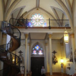
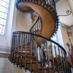
After lunch we head to the Loretto Chapel to view the miraculous staircase. When the chapel was originally built, there was no way to access the choir loft except by ladder – problematic for the nuns. They consulted local carpenters about adding a staircase but were told that the chapel was too small for a staircase. The nuns then prayed for nine days for a solution to this problem. On the ninth day, a man with a donkey, cart, toolbox, and wood appeared asking for work. To the nuns this was an answer to their prayers. When the staircase was completed several months later, the man disappeared. The staircase has no center support and was built without nails with wood not indigenous to the area. The handrails were added later by a local carpenter.
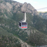
After viewing Loretto Chapel, we spend some time walking around the plaza area before heading back on I-26. Since the weather is still clear we decide to take the Sandia Tram to the 10,378 foot high Sandia Peak. The ride to the peak is breathtaking but not for anyone with a fear of heights.

On Sunday we decide to spend another quiet day at the campground. Aside from making a grocery store run and grilling some steaks for dinner that’s about as much energy as we can muster.
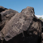
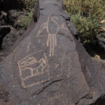
Monday morning finds us heading out to the Petroglyph National Monument. There are more than 25,000 petroglyph images carved into the rocks along the cliffs of the escarpment. Most of the images were carved by the ancient Pueblo people. No one knows for sure what the images mean. Within the park are 3 different canyons containing petroglyphs. We elect to take the trails in the Boca Negra Canyon as these are the more developed trails. Although we spot a number of images, due to the lighting most are not readily visible in our photos.
In the afternoon we drive out to the Volcanoes Day Use Area where we hike out to the JA Volcano and the Albuquerque Overlook. The overlook provides a great view of the Rio Grande Valley, Albuquerque, and the Sandia Mountains. See the panorama photo at the beginning of this post.
For our last day in Albuquerque, we first drop the dogs off for grooming and then head to the Rio Grande Nature Center State Park. The park has two miles of nature trails that loop down to the sand flats along the Rio Grande. The visitor center has a glass-walled library overlooking a pond where visitors can view geese, ducks, turtles, and other animals in their natural habitat. At the edge of the pond is a hummingbird feeder. Leaving the visitor center, we take the River Loop Trail for views of the Rio Grande.

Well, it’s time to pack up and get ready to head to our next stop. We’ve enjoyed Albuquerque and hopefully will return some day.