
Where is the Home to the Black Canyon of the Gunnison? Montrose, Colorado. We’re here for two weeks. Our original plan was to stay in Grand Junction for five days before journeying to Montrose. That plan changed as Bill was plotting our route from Colorado Springs to Grand Junction. He narrowed the route down to two options. The first option was to take I-25 into Denver and then I-70 to Colorado Springs. This route involved going through the Eisenhower-Edwin C. Johnson Memorial Tunnel and over several mountain passes. The second choice was to take US 50 through Gunnison and Montrose and over Monarch Pass. We chose the second route for some gorgeous scenery. Since the campground in Montrose had availability we decided to just stay here. We can still drive up to Grand Junction if we choose to.
The drive from Colorado Springs to Montrose on US route 50 was spectacular. We passed through Cañon City and beside Skyline Drive before entering the Royal Gorge area where we watched a number of rafters and kayakers tackling the Arkansas River. The route continued to follow the river through Bighorn Sheep Canyon until the town of Salina where we began our ascent to Monarch Pass on the Continental Divide with an elevation of 11,312 feet. The view from the pass was beautiful. Unfortunately we didn’t stop to take a photo. The descent took us through the town of Gunnison, through Blue Creek Canyon, over Blue Mesa Summit and Carroll Summit before arrivng in Montrose.
Montrose is a historic high plains town on the Western Slope of the Rocky Mountains. It is surrounded by large amounts of public land providing lots of outdoor activities and impressive views of snow covered peaks. Along Main Street are numerous shops, restaurants, pubs, and art galleries – something for everyone.
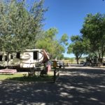

Home base for our time here is the Montrose/Black Canyon KOA and it’s really nice. It’s just a mile from downtown Montrose which makes it very convenient. The sites are gravel with nice grass lawns so we have plenty of space to spread out. There is a pool and hot tub and they have basic cable and wifi. The only problem with our site is a big birch tree that blocks our satellite signal. Yes, we are spoiled.
Since we are here earlier than originally planned and our tours are not until next week, we’ll just have to explore on our own for a while. Since there is so much to do here, I don’t think that will be a problem.
We soon discover that Ride the Rockies are in town on our first full day here so we walk into town on Thursday to check out the festival. Ride the Rockies is a multi-day cross Colorado bicycle tour that was started by the Denver Post in 1986. The route changes each year. This year the ride starts in Alamosa on June 11 and concludes in Salida on June 17.

The day before arriving in Montrose these folks had biked from Durango to Ridgway – over 80 miles with a 7700 foot elevation change. Talk about tough! We’re content to walk around the festival tents and listen to some of the participants. Just hearing their tales makes us hungry so we stop for lunch before walking back to the campground.
Even though we just arrived, Bill is already starting to plan our route from Montrose to Durango. He asks a number of folks in the campground for suggestions and everyone tells him to go through Telluride. Hum…wonder why no one thinks we should go via Ouray and Silverton on “The Million Dollar Highway” – US 550? One way to find out is to drive it with the truck sans camper. So Saturday morning we take off to investigate. We stop briefly in Ridgway to check out a potential bike ride before continuing to Ouray. The road seems fine so far.

We drive through the quaint town of Ouray but decide not to stop as we will be back next week.

The road out of town begins to climb and offers some impressive views overlooking the town.


Ok, a climb and a couple of switchbacks but not bad. There are no guard rails, the road is pretty narrow and the curves and switchbacks become more numerous as we continue so maybe dragging a camper this way is not a good idea.

There are also two tunnels which would be a tight fit for our fifth wheel. We continue on to Silverton for a late lunch (we’ll be back here as well} before retracing our route back to Montrose.
So what’s the story of the “Million Dollar Highway “? Considered one of the most dangerous roads in the US, the highway was carved out by Russian immigrant Otto Mears in the 1880s to transport ore through the San Juan Mountains from Silverton to Ouray. The origin of the name “Million Dollar Highway” is still under dispute. Some say it’s because it took a million dollars to build. Others say it’s because the fill dirt contains a million dollars in gold ore. Still others claim that it’s because they will drive it only if paid a million dollars. No matter how the name originated, the road demands respect and utmost caution. Per mile this road is considered North America’s highest avalanche hazard. East Riverside Slide at mile marker 88 claimed so many lives that in1985 a snowshed was built.


Sunday dawns as another beautiful albeit warm day so we decide to go for a bike ride. Those Ride the Rockies folks don’t have anything on us – wink! Bill maps out a route through town to a park and from there through a golf course. About halfway through our ride we stop in some shade to hydrate and grab a snack. As we head back out Bill suddenly stops and points at his tire. Yep his front tire is flat as a pancake and won’t hold air when he attempts to inflate it using his hand pump. Strange, it was fine until we stopped. Now, we’re a few miles from “home” so, do we push the bikes back, call for a taxi, or split up? We choose to split up, so Bill rides my bike “home” while I wait for him to come back with the truck. I have a shady spot, water, and my cellphone so I’m content.
Monday we head to the Black Canyon of the Gunnison National Park – proclaimed a national monument in 1933 and a national park in 1999.
“Black Canyon of the Gunnison exposes you to some of the steepest cliffs, oldest rock, and craggiest spires in North America. ” — nps
We enter the park along the South Rim Road and stop at Tomichi Point before continuing on to the South Rim Visitor Center where we watch a short film detailing the history of the park, pick up a map and walk down to Gunnison Point overlook. There are 12 overlooks along the road, most with trails ranging from 100 to 1700 yards. It’s hot and the elevation is over 8000 feet so we pick and choose the trails we want to attempt.


As we’re leaving the Black Canyon I mention that I’m disappointed that we haven’t seen much wildlife. Look what we find around the next bend.

We decide that Tuesday is a good day for another bike ride. A local bike shop fixed Bill’s flat so we’re good to go – or are we? As Bill pulls my bike around he notices that my rear tire is – you guessed it – flat. We had the bikes serviced before we left home so two flats in as many days is a real puzzlement. We load both bikes in the truck bed and head to the bike shop where Bill asks them to replace all of the tubes. How about a lazy day in the campground instead of biking?

We have two jeep tours scheduled with Switzerland of America Scenic Tours based in Ouray. We originally arranged afternoon tours but when Bill called to confirm they recommended morning tours for better lighting, cooler weather, and the possibility of seeing more wildlife. So we’re up early Wednesday morning for the 45 minute drive to Ouray and our Yankee Boy Basin tour. We’re assigned an open air jeep with our driver/guide Lynn and 6 fellow adventurers. We all clamor aboard and off we go.
Our route takes us over the Box Canyon Gorge where ice climbing competitions are held in the winter and up Canyon Creek road. We pass through canyons and view a number of waterfalls that our guide tells us will soon dry up as the snow melts away.

We actually get a shower as we pass under an outcropping called “The Overhang.” Along the way we view several mines – some still in operation and some – like this one – not.

Once in the basin we have a great view of a semi circle of 13,000 to 14,000 foot high mountain peaks of the Sneffels Mountain Range.


After taking in the beauty of the basin, we start our descent along the same route stopping to admire a few waterfalls.


This tour is the mildest tour that the company offers but we bounce around quite a bit as the jeep climbs over rocks and plows through creeks and gullies. A good portion of the route is on a county road that carries a warning “all wheel drive high clearance vehicles only.” Lynn tells us that they have to stop and help motorists that ignor the warning quite often.

Back in Ouray we grab a bite to eat at Maggie’s Kitchen (great burgers by the way) and then wander through some of the shops. We have to save some for when we come back later this week so we head back to Montrose mid afternoon. Our plan is to cleanup and relax before catching an evening movie.
Would you believe that Montrose has a real old fashioned drive in? It’s family owned and has been in operation for over 60 years. They’ve upgraded to digital projection and stereo sound (if you tune your fm dial appropriately) but you can still place a speaker on your window if you so choose. This is really a blast from the past! Don’t forget the popcorn and soda from the concession stand!

It’s been a busy week and we are not done yet. Stay tuned for more adventures from Montrose …..