
July 13 – 19
This week we are in Page, Arizona where it is HOT (triple digits during the day). The trip from Mesa Verde along US 160 and US 98 took about four and one half hours with a change in elevation from 7800 feet above sea level at Morefield Campground to 3800 feet at Wahweap Campground. Not only did the elevation change but the scenery changed dramatically – from semi arid green to desert tan, from distant mountains views to flat lands to sudden towers and canyon walls.

As we approach the Glen Canyon Recreation Area we cross the bridge and have a first view of Glen Canyon, Glen Canyon Dam, Lake Powell, and the Colorado River.


Glen Canyon Dam is a concrete arch-gravity dam on the Colorado River in northern Arizona, United States, near the town of Page. The 710 foot high dam was built by the U.S. Bureau of Reclamation from 1956 to 1966 and forms Lake Powell, one of the largest man-made reservoirs in the U.S. with a capacity of 27 million acre feet. The dam is named for Glen Canyon, a series of deep sandstone gorges now flooded by the reservoir; Lake Powell is named for John Wesley Powell, who in 1869 led the first expedition to traverse the Colorado’s Grand Canyon by boat. — Wikipedia
 Wahweap Campground is located on the banks of Lake Powell in the Glen Canyon National Recreation Area just outside of Page. The campground has 139 full hook-up sites plus tent and self-contained RV sites. We have site A-3 with a great view of the lake. There is also a beach, marina, lodge, and resort with restaurants and shops. Compared to the quiet and solitude of Morefield this is a hub of activity.

The next day (Friday) dawns early as Arizona does not observe Daylight Savings Time. To give us some shade we extend the awning, strap it down using stakes and zip on the sunscreen. Hopefully this will provide some shaded living space. Next we head over to the resort to confirm our evening panoramic boat tour before driving into town to replenish our provisions. Later in the afternoon a major wind suddenly pops up that rips out the awning stakes and threatens to damage the awning. Fortunately we are able to wrestle it closed. Lesson learned – don’t count on using an awning here and, if you do, be ready to retract it.
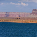
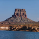
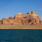
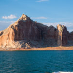
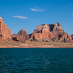
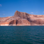
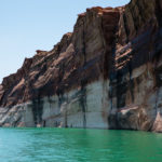
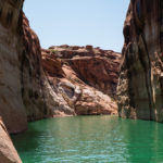
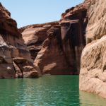
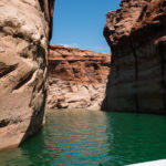
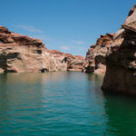
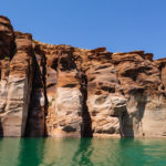
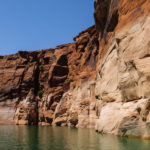
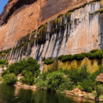
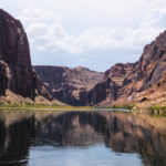
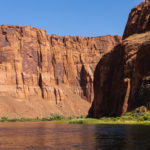
In the evening we return to the resort for the two hour Panoramic Lake Powell Cruise. Upon boarding we are given headsets and receivers for the audio narration. It’s open seating so we climb the stairs to the open upper deck for the best views. Our cruise takes us past Castle Rock, Tower Butte and Gunsight Butte into Gunsight Bay. The water is turquoise and clear while the canyon walls and outcropping are a myriad of orange, red, pink, beige, and white. There’s a picture perfect view everywhere we look. The narration tells about the exploration of the Canyon by Powell, the decision to build the dam, the construction of the bridge, and points of interest along our route.
Following the cruise we have dinner in the Driftwood Lounge at the resort and enjoy the sunset.
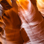
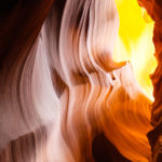
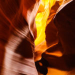
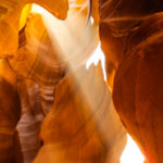
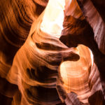
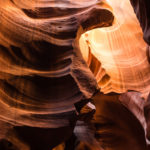
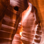
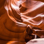
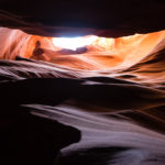
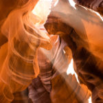
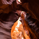
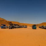
Saturday morning we drive into Page for our Upper Antelope Slot Canyon tour with Antelope Canyon Tours. At 9:30 our driver/guide loads us and 12 other folks onto our tour vehicle and off we go. The trip to the canyon follows paved streets until we go off-road on a bumpy, sandy stretch. We only see one vehicle stuck in the sand on this stretch and fortunately it is not loaded with tourists. When we arrive, our guide walks with us to the entrance where he explains the dos and don’ts and helps us with our camera settings. He then leads us through, stopping along the way to point out the best spots for photographs. The formations, textures, and lighting are amazing.


Sunday we decide to tour the Glen Canyon Dam. Tours are available from the Visitor Center. Backpacks, purses, food, and beverages other than a water bottle are prohibited on the tour. We pass through a metal detector before meeting our escort. From the Visitor Center we descend via elevator to the top of the dam. After walking halfway across the top, we descend by another elevator several stories into the dam to view service corridors and the turbine room. The temperature in this area of the dam is in the 50s and everyone is reluctant to return to the top and back to the Visitor Center.


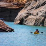
We were supposed to go on the Canyons Adventure Cruise Monday morning but were notified that the boat was broken so we switched to the Antelope Canyon Cruise. The Antelope Canyon Cruise is a 1.5 hour cruise that gets close to the dam before entering the twisting Antelope Canyon. Whereas the Panoramic cruise emphasized the grand scale of the lake, this cruise emphasizes the small scale. The curves are tight and the Canyon walls impressive.
While on the top of the dam Sunday looking down at the river we spotted several small blue rafts and folks loading supplies. Further investigation online and in a friend’s trip documents (thanks Jon and Barb) leads us to Colorado River Discovery’s Half Day Raft Trip. We give them a quick call and sign up for their Tuesday 1:00 p.m. trip.
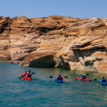
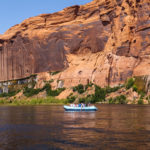
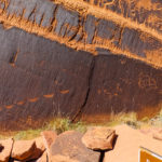
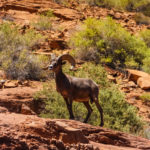
Tuesday afternoon we arrive 30 minutes early for our raft trip, sign-in, and board a bus for the trip through the tunnel. The 2 mile tunnel was carved through the rock for the transport of the turbines and other materials for the dam. They hand each of us a hard hat as we exit the bus – required as the walk to the rafts is under the roadway and along the rock face. We deposit the hard hats in a bin and climb aboard one of the waiting rafts. Each raft accommodates about 15 plus the guide. Our guide, Oscar, explains the safety features, points out the coolers with water, and starts the motor – no rowing here. As we travel, he often shuts off the motor to allow us to drift, look, and listen. This trip provides a glimpse of how the canyon appeared before Lake Powell was created. It’s a great opportunity to look up at the canyon walls, spot bighorn sheep, cool off in really cold 47 degree river water, and hike up to view some petroglyphs.
Our last full day here starts with a quiet relaxing morning. In the afternoon we make a trip into Page to top off our supplies. In the evening I bribe Bill (with pizza) to take me out to Horseshoe Bend for a sunset photograph. When we arrive at the access point the parking lot is packed. We manage to find a place for the truck, grab our cameras and water bottles, and set off on the 1.5 mile round-trip hike. The trail is sand and rock with quite a bit of up followed by an equal amount of down. The overlook has an elevation of 4300 feet with a 1000 foot drop to the Colorado River. There are folks spread out everywhere, some precariously close to the edge.


As we reflect on our time here, we are still surprised by the number of foreign visitors that we encountered. We met folks from Norway, Switzerland, Italy, and Japan. It seemed that on the Horseshoe Bend hike alone only 1 out of 4 conversations were in English. Everywhere parking lots are full of rental vehicles. On the roads and in the campground 2 out of 3 RVs are clearly rentals (Cruise America, El Monte RV, or roadbearrv Class Cs). This is definitely a popular destination..
Now it’s time for the sun to set on our Lake Powell adventure. See you at our next destination.
