
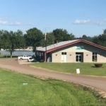
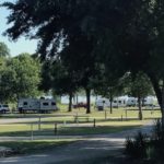
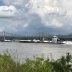
This week we’re in Natchez, Mississippi. We are camping at River View RV Park and Resort which is actually across the river from Natchez in Vidalia, Louisiana. The campground is on the bank of the Mississippi River and we can watch the barges as they travel up and down the river. We were a bit concerned about coming here as the Mississippi is above flood stage but a quick call to the campground assured us that all was well. We did see a depth marker nearby that registered 51 feet (3 feet above flood stage).
For our introduction to Natchez, we took Karla Brown’s Drive Around Natchez Tour (Downtown Karla Brown). This is a two hour driving tour that gives a great overview of the history and important sites of the city. Karla also provides a checklist of things to do while in Natchez as well as places to eat. I’m not sure that a week is sufficient time to do everything that she recommends but we’ll give it a try.
Our first choice from her checklist is a scenic drive along the Natchez Trace Parkway. The Parkway is 444 miles long and links Natchez, Mississippi to Nashville, Tennessee. Needless to say, we’re only going to do a short segment of the drive.
The Trace has a very interesting history. What started as a migration path for large animals, expanded into a trade route for various Indian tribes. In the 1800’s the underbrush was removed and bridges built so that the Trace could be used as a postal route. It also enabled “flatboaters” to ride or walk back north after piloting their flat wooden boats full of goods down the Mississippi River. Since these boats could not navigate upriver against the current, they were torn apart and sold as lumber. The Parkway, as it is today, was started in 1937 and adopted by the National Park Service in 1938.
Our first stop along the Trace is the Emerald Mound. Built by the ancestors of the Natchez Indians, this mound is approximately 770 feet long, 435 feet wide, and 35 feet high. It was used as a ceremonial mound from about 1250 until 1600 AD when the tribe for unknown reasons moved their ceremonial center to the Grand Village in Natchez.
Our second stop is Mount Locust which is the only remaining inn from the 50 or more that once existed along the Trace.

At this point, it’s almost lunchtime so we decide to take a detour over to Route 61 for a stop at the Old Country Store in Lorman, Mississippi (one of Karla’s recommendations). Mr. D’s fried chicken is absolutely delicious and well-worth the small detour. Be sure to check it out on Facebook or YouTube.

After lunch we continue on to Windsor Ruins. Our guidebook gives us a street address for the ruins so we follow our GPS to the ruins off of MS 552. The four story house on Windsor Plantation was finished in 1861. The house had 25 rooms and 25 fireplaces. During the Civil War Windsor was used as a Union hospital and survived the war intact. Ironically, on Feb. 17, 1890 a party guest dropped a cigarette on the third floor and the house burned to the ground. Only a few pieces of china, the 23 columns, and the balustrade remain.


Following our visit to Windsor Ruins we decide to backtrack via GPS to Springfield Plantation. Big mistake. Our GPS takes us on a 5 mile adventure on a one lane dirt road complete with a creek that we must cross. Eventually we find Springfield but, even though it has been restored, it’s not open to the public. The best we can do is walk around the outside. This seems like a good time to head back to the campsite for the night.